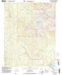
2004 Map of Sharktooth Peak
USGS Topo · Published 2007About this map
Silver Divide dominates the northern reaches of this high-altitude landscape, where the John Muir Wilderness meets the Ansel Adams Wilderness. The terrain is defined by a dense network of alpine water bodies, including the clusters of the Margaret Lakes and Sharktooth Lake, all feeding into drainages like Silver Creek and the South Fork San Joaquin River. In the lower elevations, the Onion Springs OHV Route provides motorized access toward the shore of Thomas A Edison Lake, where the Vermilion Valley Resort serves as a lone outpost of human infrastructure. Significant mountain meadows such as Onion Spring Meadow and Fawn Meadow break up the granite slopes, illustrating the high Sierras' summer grazing and recreational character at the start of the 21st century.
Find a feature on this map
54 named features on this map. Tap any name to fly to it.
Don’t see what you’re looking for? This feature index may not catch every label — zoom into the map to look around manually.
Map Details
Editions of this 2004 Sharktooth Peak Map
This is the sole edition of this map. No revisions or reprints were ever made.
Other maps of this area

1901 · Mt. Lyell
USGS Topo · 1:125,000

1904 · Kaiser
USGS Topo · 1:125,000

1912 · Mt. Goddard
USGS Topo · 1:125,000

1914 · Mt. Morrison
USGS Topo · 1:125,000

1947 · Mariposa
USGS Topo · 1:250,000

1948 · Mariposa
USGS Topo · 1:250,000

1953 · Mt. Morrison
USGS Topo · 1:62,500

1953 · Mt Abbot
USGS Topo · 1:62,500

1953 · Devils Postpile
USGS Topo · 1:62,500

1953 · Kaiser Peak
USGS Topo · 1:62,500