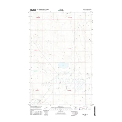
2017 Map of Sharp Lake
USGS Topo · Published 2017About this map
Sharp-Nightshoot Cem sits at the heart of this high plains landscape in Glacier County, marking a site of local heritage near the Sharp Trl. The geography is defined by a network of drainage features like Hoodoo Coulee and Boundary Cr that feed into the prominent Cut Bank Creek system. The presence of Boarding School Rd and the Blackfoot Cutoff in the southern portion of the map suggests historical transport corridors and institutional footprints essential to the local community. Sharp Lake and the nearby Greasewood Flat illustrate the seasonal hydrology of this area, where intermittent streams such as N Fork Greasewood Cr and S Fork Greasewood Cr converge. Ranches and local access are traced through named thoroughfares like Finley Ranch Rd, providing a clear record of 21st-century land use and connectivity.
Find a feature on this map
24 named features on this map. Tap any name to fly to it.
Don’t see what you’re looking for? This feature index may not catch every label — zoom into the map to look around manually.
Map Details
Editions of this 2017 Sharp Lake Map
This is the sole edition of this map. No revisions or reprints were ever made.
Other maps of this area

1901 · Browning
USGS Topo · 1:125,000

1903 · Browning
USGS Topo · 1:125,000

1911 · Blackfoot
USGS Topo · 1:125,000

1960 · Cut Bank
USGS Topo · 1:250,000

1963 · Cut Bank
USGS Topo · 1:250,000

1964 · Cut Bank
USGS Topo · 1:250,000

1968 · Rimrock Butte
USGS Topo · 1:24,000

1968 · Hoodoo Hill
USGS Topo · 1:24,000

1968 · Browning NE
USGS Topo · 1:24,000
1968 · Browning
USGS Topo · 1:24,000