
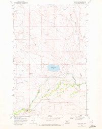
1968 Map of Rimrock Butte
USGS Topo · Published 1972About this map
Square Butte and Rimrock Butte dominate this section of Glacier County, rising as prominent landmarks above the drainages of the Blackfeet Indian Reservation. The landscape is defined by the winding course of Cut Bank Creek, which flows eastward across the southern portion of the quadrangle. This watercourse is supported by an intricate network of coulees and irrigation infrastructure, including the Cobell Ditch and the long reach of Cobell Coulee.
Find a feature on this map
11 named features on this map. Tap any name to fly to it.
Don’t see what you’re looking for? This feature index may not catch every label — zoom into the map to look around manually.
Map Details
Editions of this 1968 Rimrock Butte Map
This is the sole edition of this map. No revisions or reprints were ever made.
Other maps of this area

1911 · Blackfoot
USGS Topo · 1:125,000

1960 · Cut Bank
USGS Topo · 1:250,000

1963 · Cut Bank
USGS Topo · 1:250,000

1964 · Cut Bank
USGS Topo · 1:250,000

1968 · Buffalo Lake
USGS Topo · 1:24,000
1968 · Kipp Lake
USGS Topo · 1:24,000
1968 · Mission Lake West
USGS Topo · 1:24,000
1968 · Blackfoot
USGS Topo · 1:24,000
1968 · Fort Piegan
USGS Topo · 1:24,000
1968 · Sharp Lake
USGS Topo · 1:24,000