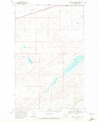
1968 Map of Mission Lake West
USGS Topo · Published 1972About this map
The Blackfeet Indian Reservation defines this landscape in Glacier County, where an intricate water management system of canals and reservoirs supports the high plains. Large water bodies including Mission Lake and Upper Mission Lake are central features, connected by the Main Canal which cuts through the semi-arid terrain. The southern portion of the map is dominated by the winding course of the Two Medicine River and its accompanying Two Medicine Coulee, while the northern region is characterized by the broad expanse of Seville Flat. Local hydrologic features like Lamott Springs and Guardipee Lake provide essential water sources in a region where the Burlington Northern railroad corridor parallels the Northern Coulee, facilitating transport across this northern Montana territory during the late 1960s.
Find a feature on this map
18 named features on this map. Tap any name to fly to it.
Don’t see what you’re looking for? This feature index may not catch every label — zoom into the map to look around manually.
Map Details
Editions of this 1968 Mission Lake West Map
This is the sole edition of this map. No revisions or reprints were ever made.
Other maps of this area

1911 · Blackfoot
USGS Topo · 1:125,000

1914 · Heart Butte
USGS Topo · 1:125,000

1918 · Heart Butte
USGS Topo · 1:125,000

1960 · Cut Bank
USGS Topo · 1:250,000

1963 · Cut Bank
USGS Topo · 1:250,000

1964 · Cut Bank
USGS Topo · 1:250,000
1968 · Piegan
USGS Topo · 1:24,000

1968 · Rimrock Butte
USGS Topo · 1:24,000

1968 · White Man Coulee
USGS Topo · 1:24,000
1968 · Rocky Ridge
USGS Topo · 1:24,000