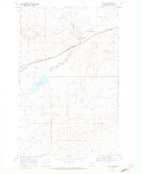
1968 Map of Kipp Lake
USGS Topo · Published 1972About this map
The Blackfeet Indian Reservation landscape is defined here by the transit corridor of the Burlington Northern railroad and the Burlington Northern and Clark Trail, which both cut through the northern half of this 1968 study. The settlement of Blackfoot sits at the western edge of the sheet, while the rail stops at Meriwether and the southern settlement of Family mark the sparsely populated terrain.
Find a feature on this map
16 named features on this map. Tap any name to fly to it.
Don’t see what you’re looking for? This feature index may not catch every label — zoom into the map to look around manually.
Map Details
Editions of this 1968 Kipp Lake Map
This is the sole edition of this map. No revisions or reprints were ever made.
Other maps of this area

1911 · Blackfoot
USGS Topo · 1:125,000

1914 · Heart Butte
USGS Topo · 1:125,000

1918 · Heart Butte
USGS Topo · 1:125,000

1960 · Cut Bank
USGS Topo · 1:250,000

1963 · Cut Bank
USGS Topo · 1:250,000

1964 · Cut Bank
USGS Topo · 1:250,000
1968 · Piegan
USGS Topo · 1:24,000

1968 · Rimrock Butte
USGS Topo · 1:24,000

1968 · White Man Coulee
USGS Topo · 1:24,000
1968 · Magee Ranch
USGS Topo · 1:24,000