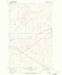
1968 Map of Blackfoot
USGS Topo · Published 1972About this map
The Blackfeet Indian Reservation terrain in northwestern Montana is defined by the sweeping transition from high plains to the Rocky Mountain foothills. The settlement of Blackfoot serves as a focal point along the Burlington Northern railroad, featuring a Depot that historically linked this remote ranching and tribal land to broader markets. The presence of the Lewis and Clark Trail cutting diagonally across the landscape highlights the enduring importance of this corridor for transcontinental travel and exploration. Local hydrology is marked by the branching drainage of Flatiron Creek and Willow Creek, which flow through a landscape of coulees and seasonal springs. Evidence of previous infrastructure persists in the form of an Old Railroad Grade, while the modern industrial footprint is seen in scattered Gravel Pits and a prominent Pipeline crossing the northern sections.
Find a feature on this map
19 named features on this map. Tap any name to fly to it.
Don’t see what you’re looking for? This feature index may not catch every label — zoom into the map to look around manually.
Map Details
Editions of this 1968 Blackfoot Map
This is the sole edition of this map. No revisions or reprints were ever made.
Other maps of this area

1901 · Browning
USGS Topo · 1:125,000

1903 · Browning
USGS Topo · 1:125,000

1911 · Blackfoot
USGS Topo · 1:125,000

1913 · Marias Pass
USGS Topo · 1:125,000

1914 · Heart Butte
USGS Topo · 1:125,000

1918 · Heart Butte
USGS Topo · 1:125,000

1960 · Cut Bank
USGS Topo · 1:250,000

1963 · Cut Bank
USGS Topo · 1:250,000

1964 · Cut Bank
USGS Topo · 1:250,000

1968 · Rimrock Butte
USGS Topo · 1:24,000