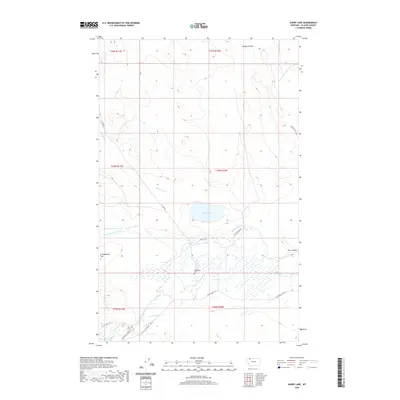
2020 Map of Sharp Lake
USGS Topo · Published 2020About this map
Sharp Lake and the winding course of Cut Bank Creek define this section of Glacier County, characterized by a complex network of coulees and flats. The landscape is marked by land-use patterns typical of the region, where ranching access roads like Finley Ranch Rd and 3 C Bar RD intersect with traditional routes such as the Blackfoot Cutoff and the Sharp Trl. Near the center of the sheet, the Nightshoot Cem provides a specific point of interest for genealogical research and local history.
Find a feature on this map
25 named features on this map. Tap any name to fly to it.
Don’t see what you’re looking for? This feature index may not catch every label — zoom into the map to look around manually.
Map Details
Editions of this 2020 Sharp Lake Map
This is the sole edition of this map. No revisions or reprints were ever made.
Other maps of this area

1901 · Browning
USGS Topo · 1:125,000

1903 · Browning
USGS Topo · 1:125,000

1911 · Blackfoot
USGS Topo · 1:125,000

1960 · Cut Bank
USGS Topo · 1:250,000

1963 · Cut Bank
USGS Topo · 1:250,000

1964 · Cut Bank
USGS Topo · 1:250,000

1968 · Rimrock Butte
USGS Topo · 1:24,000

1968 · Hoodoo Hill
USGS Topo · 1:24,000

1968 · Browning NE
USGS Topo · 1:24,000
1968 · Browning
USGS Topo · 1:24,000