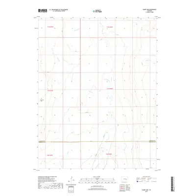
2019 Map of Sharp Lake
USGS Topo · Published 2019About this map
The high plains of eastern Colorado, where the Lincoln Co-Crowley Co line divides the landscape, define this 2019 survey. The area is characterized by a network of seasonal drainage and intermittent water bodies, most notably Sharp Lake in the northeast and the expansive Ninemile Flats to the west. This territory is primarily rural, organized by the Public Land Survey System into townships like t17s r56w and t18s r57w. A series of local routes, including Co RD A and Field RD, provide access across the dry terrain, following the natural contours of the land around Horse Cr and its tributaries. The sparse distribution of named features suggests a landscape dedicated to large-scale ranching or open range, where water sources like Pond Cr and Steels Fork are critical landmarks for navigation and land management.
Find a feature on this map
19 named features on this map. Tap any name to fly to it.
Don’t see what you’re looking for? This feature index may not catch every label — zoom into the map to look around manually.
Map Details
Editions of this 2019 Sharp Lake Map
This is the sole edition of this map. No revisions or reprints were ever made.
Other maps of this area

1889 · Sanborn
USGS Topo · 1:125,000

1891 · Sanborn
USGS Topo · 1:125,000

1891 · Catlin
USGS Topo · 1:125,000

1893 · Sanborn
USGS Topo · 1:125,000

1893 · Catlin
USGS Topo · 1:125,000

1954 · Lamar
USGS Topo · 1:250,000

1958 · Lamar
USGS Topo · 1:250,000

1977 · Walker Point
USGS Topo · 1:24,000
1977 · The Pinnacles
USGS Topo · 1:24,000
1977 · Box Springs
USGS Topo · 1:24,000