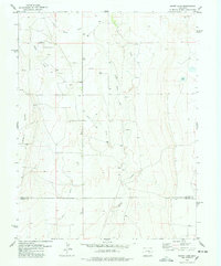
1978 Map of Sharp Lake
USGS Topo · Published 1978About this map
Ninemile Flats dominates the western portion of this landscape, reflecting the broad, open topography found along the border of Lincoln Co and Crowley Co. The area is defined by its drainage systems, most notably the meandering paths of Steels Fork and Little Horse Creek which converge toward the south as Horse Creek. Scattered Springs and an isolated Pond suggest the importance of groundwater in this semi-arid region, where land management is evidenced by the numerous wells and fine fence lines marked across the township sections. A singular Gravel Pit provides a glimpse into the local extraction needs of the late 1970s. Further east, the namesake Sharp Lake sits near the upper reaches of another unnamed drainage, while various storage tanks are positioned across the high ground to support livestock and agricultural operations.
Find a feature on this map
10 named features on this map. Tap any name to fly to it.
Don’t see what you’re looking for? This feature index may not catch every label — zoom into the map to look around manually.
Map Details
Editions of this 1978 Sharp Lake Map
This is the sole edition of this map. No revisions or reprints were ever made.
Other maps of this area

1889 · Sanborn
USGS Topo · 1:125,000

1891 · Sanborn
USGS Topo · 1:125,000

1891 · Catlin
USGS Topo · 1:125,000

1893 · Sanborn
USGS Topo · 1:125,000

1893 · Catlin
USGS Topo · 1:125,000

1954 · Lamar
USGS Topo · 1:250,000

1958 · Lamar
USGS Topo · 1:250,000

1977 · Walker Point
USGS Topo · 1:24,000
1977 · The Pinnacles
USGS Topo · 1:24,000
1977 · Box Springs
USGS Topo · 1:24,000