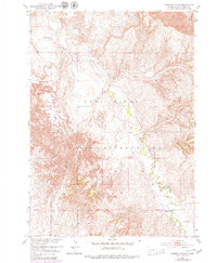
1951 Map of Sharps Corner
USGS Topo · Published 1979About this map
Pine Ridge Indian Reservation land is defined by the winding course of Porcupine Creek, which cuts through the high plains and breaks of the White River Basin. The landscape features notable natural landmarks such as Chimney Butte, providing a distinct vertical reference in a region of complex contouring and erosional relief. This 1951 survey, later updated in 1979, illustrates the dispersed community structure characteristic of the era. The small settlement at Sharps Corner serves as a primary local junction, while the presence of Rockyford Ch and St Luke Ch reflects the vital role of rural parish life in the early post-war period. These community centers and scattered dwellings are linked by an evolving network of unimproved dirt and light-duty roads, marking the transition from traditional horse-and-wagon routes to modern automotive access across the reservation.
Find a feature on this map
10 named features on this map. Tap any name to fly to it.
Don’t see what you’re looking for? This feature index may not catch every label — zoom into the map to look around manually.
Map Details
Editions of this 1951 Sharps Corner Map
2 editions found
Other maps of this area

1950 · Stirk Table
USGS Topo · 1:24,000

1950 · Imlay SW
USGS Topo · 1:24,000

1950 · Imlay SE
USGS Topo · 1:24,000

1951 · Sharps Corner
USGS Topo · 1:24,000

1951 · Rockyford
USGS Topo · 1:24,000

1951 · Rockyford SE
USGS Topo · 1:24,000

1955 · Hot Springs
USGS Topo · 1:250,000

1981 · Wall
USGS Topo · 1:100,000

1981 · Evergreen
USGS Topo · 1:25,000

1981 · Evergreen NE
USGS Topo · 1:24,000