
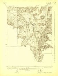
1922 Map of Shasta Valley Sheet No 10
USGS Topo · Published 1922About this map
The Shasta River cuts through this volcanic landscape of Siskiyou County, where the terrain is defined by numerous small, isolated hills and complex contour patterns typical of the region. Local education and infrastructure are anchored by the centrally located Shasta View School, which served the rural population during this era of agricultural development. The industrial presence of the California Oregon Power Company and the transportation corridor of the Pacific Branch rail line indicate the early 20th-century push to modernize the valley. Surveyed in cooperation with the Klamath-Shasta Valley Irrigation District, the map reflects a period of intense focus on water management and land reclamation efforts in northern California.
Find a feature on this map
4 named features on this map. Tap any name to fly to it.
Don’t see what you’re looking for? This feature index may not catch every label — zoom into the map to look around manually.
Map Details
Editions of this 1922 Shasta Valley Sheet No 10 Map
This is the sole edition of this map. No revisions or reprints were ever made.
Other maps of this area

1886 · Shasta
USGS Topo · 1:250,000

1894 · Shasta
USGS Topo · 1:250,000

1921 · Shasta Valley Sheet No 7
USGS Topo · 1:24,000

1921 · Shasta Valley Sheet No 11
USGS Topo · 1:24,000

1921 · Shasta Valley Sheet No 6
USGS Topo · 1:24,000

1922 · Shasta Valley Sheet No 10 E
USGS Topo · 1:24,000

1922 · Shasta Valley Sheet No 9
USGS Topo · 1:24,000
1922 · Shasta Valley Sheet No 8
USGS Topo · 1:24,000

1934 · Macdoel
USGS Topo · 1:96,000

1935 · Dunsmuir
USGS Topo · 1:125,000