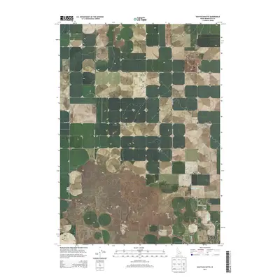
2013 Map of Shattuck Butte
USGS Topo · Published 2013About this map
Oakland Valley sits in the southeastern portion of this Idaho landscape, where the agricultural character of Bonneville County is defined by an intricate network of irrigation systems. The Oakland Canal and Martin Canal weave through the valley, providing the vital water infrastructure necessary for farming in this high-altitude terrain. Dominating the northeastern quadrant, the volcanic profile of Shattuck Butte serves as a prominent natural landmark overlooking the surrounding sections. A sparse network of range roads, including W 129 N and W 81st N, segment the land into a traditional grid, while the W Arco Hwy cuts a diagonal path across the southwestern corner, connecting the area to broader regional hubs. The presence of the QB One Airport in the west further reflects the modern logistical needs of this rural expanse.
Find a feature on this map
19 named features on this map. Tap any name to fly to it.
Don’t see what you’re looking for? This feature index may not catch every label — zoom into the map to look around manually.
Map Details
Editions of this 2013 Shattuck Butte Map
This is the sole edition of this map. No revisions or reprints were ever made.
Other maps of this area

1948 · Woodville
USGS Topo · 1:24,000

1948 · Lewisville
USGS Topo · 1:24,000

1948 · Idaho Falls North
USGS Topo · 1:24,000

1948 · Idaho Falls South
USGS Topo · 1:24,000

1949 · Idaho Falls North
USGS Topo · 1:24,000

1949 · Lewisville
USGS Topo · 1:24,000

1949 · Roberts
USGS Topo · 1:62,500

1949 · Roberts
USGS Topo · 1:24,000

1949 · Shattuck Butte
USGS Topo · 1:24,000

1950 · Shattuck Butte
USGS Topo · 1:24,000