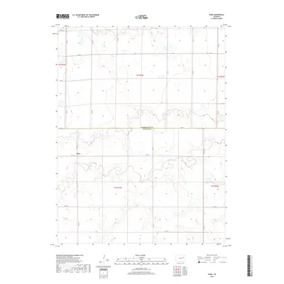
2019 Map of Shaw
USGS Topo · Published 2019About this map
Shaw is situated in the high plains of Eastern Colorado, marking a quiet junction of rural section lines along the border of Lincoln and Washington counties. This map details the headwaters and drainage of the North Fork Arikaree River, where the seasonal flow has carved subtle depressions into the arid landscape. The area is defined by a grid of agricultural section roads, most notably Co Rd 4, which provides the primary north-south transit corridor through this ranching country. Gordon Creek enters the frame in the northwest, winding through a series of intermittent wetlands and stock ponds that characterize the local hydrology. The layout illustrates the sparse settlement pattern and large-scale land divisions common to the region, preserving the names and paths of the high plains just before the turn of the decade.
Find a feature on this map
3 named features on this map. Tap any name to fly to it.
Don’t see what you’re looking for? This feature index may not catch every label — zoom into the map to look around manually.
Map Details
Editions of this 2019 Shaw Map
This is the sole edition of this map. No revisions or reprints were ever made.
Other maps of this area

1954 · Limon
USGS Topo · 1:250,000

1957 · Limon
USGS Topo · 1:250,000

1958 · Limon
USGS Topo · 1:250,000

1973 · Lindon NE
USGS Topo · 1:24,000

1973 · Lindon SW
USGS Topo · 1:24,000

1973 · Lindon
USGS Topo · 1:24,000

1973 · Shaw
USGS Topo · 1:24,000

1977 · Thurman
USGS Topo · 1:24,000
1978 · Anton
USGS Topo · 1:24,000

1979 · Arriba NW
USGS Topo · 1:24,000