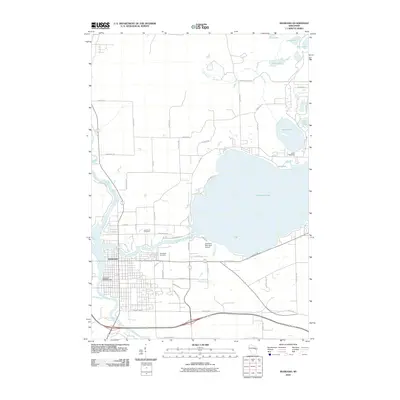
2010 Map of Shawano
USGS Topo · Published 2010About this map
The city of Shawano serves as the focal point of this 2010 survey, situated at the confluence of the Wolf River and the Shawano Lake Outlet. The landscape is defined by the massive expanse of Shawano Lake to the east and a chain of smaller northern waters including Loon Lake, Lulu Lake, and Rice Lake. This geography dictates a settlement pattern where residential developments like Cattau Beach Dr and Homewood Ave hug the lakefronts, while the southern part of the city transitions into an industrial and transit corridor along Industrial Dr and the Shawano Municipal Airport. Local history and genealogy interests are well-represented by the prominent Woodlawn Cemetery and Lake Drive Cemetery, as well as the Shawano 3WR393 Dam which manages the water flow through the heart of the community. In the northeast, Camp Tekawitha occupies the shores of Loon Lake, illustrating the area's long-standing role as a recreational destination.
Find a feature on this map
55 named features on this map. Tap any name to fly to it.
Don’t see what you’re looking for? This feature index may not catch every label — zoom into the map to look around manually.
Map Details
Editions of this 2010 Shawano Map
This is the sole edition of this map. No revisions or reprints were ever made.
Other maps of this area

1954 · Shawano
USGS Topo · 1:48,000

1955 · Embarrass
USGS Topo · 1:48,000

1955 · Seymour
USGS Topo · 1:62,500

1955 · Green Bay
USGS Topo · 1:250,000

1956 · Gillett
USGS Topo · 1:62,500

1964 · Shawano
USGS Topo · 1:62,500

1969 · Embarrass
USGS Topo · 1:24,000

1969 · Lunds
USGS Topo · 1:24,000

1974 · Cecil
USGS Topo · 1:24,000
1974 · Berry Lake
USGS Topo · 1:24,000