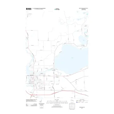
2013 Map of Shawano
USGS Topo · Published 2013About this map
The city of Shawano serves as the hub of this Wolf River Valley landscape, positioned where the Wolf River meets the Shawano Lake Outlet. The expansive Shawano Lake dominates the eastern half of the map, its shoreline dotted with access points and recreational landmarks such as Camp Tekawitha on the northern shore. The transition from the urban grid of Shawano to the surrounding rural and lakeside terrain is marked by essential infrastructure, including the Shawano Municipal Airport and the Shawano Landfill.
Find a feature on this map
106 named features on this map. Tap any name to fly to it.
Don’t see what you’re looking for? This feature index may not catch every label — zoom into the map to look around manually.
Map Details
Editions of this 2013 Shawano Map
This is the sole edition of this map. No revisions or reprints were ever made.
Other maps of this area

1954 · Shawano
USGS Topo · 1:48,000

1955 · Embarrass
USGS Topo · 1:48,000

1955 · Seymour
USGS Topo · 1:62,500

1955 · Green Bay
USGS Topo · 1:250,000

1956 · Gillett
USGS Topo · 1:62,500

1964 · Shawano
USGS Topo · 1:62,500

1969 · Embarrass
USGS Topo · 1:24,000

1969 · Lunds
USGS Topo · 1:24,000

1974 · Cecil
USGS Topo · 1:24,000
1974 · Berry Lake
USGS Topo · 1:24,000