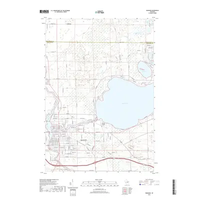
2018 Map of Shawano
USGS Topo · Published 2018About this map
Shawano serves as the primary hub of this 2018 survey, situated where the Wolf River meets the expansive southern shores of Shawano Lake. The map illustrates a landscape shaped by water and woodland, documenting the transition from the city's dense grid to the more dispersed lakeside developments along Cattau Beach Rd and N Shore Dr. North of the city, the boundary between Menominee and Shawano counties marks a shift toward the tribal lands near Keshena, characterized by dense clusters of small lakes like Rice Lake, Loon Lake, and Deer Spring Lake. Genealogists will find the locations of Woodlawn Cem and Lake Drive Cem particularly useful, while the inclusion of the Shawano Municipal Airport and the complex drainage of the Shawano Lake Outlet provide insight into the modern infrastructure and hydrology of the region.
Find a feature on this map
141 named features on this map. Tap any name to fly to it.
Don’t see what you’re looking for? This feature index may not catch every label — zoom into the map to look around manually.
Map Details
Editions of this 2018 Shawano Map
This is the sole edition of this map. No revisions or reprints were ever made.
Other maps of this area

1954 · Shawano
USGS Topo · 1:48,000

1955 · Embarrass
USGS Topo · 1:48,000

1955 · Seymour
USGS Topo · 1:62,500

1955 · Green Bay
USGS Topo · 1:250,000

1956 · Gillett
USGS Topo · 1:62,500

1964 · Shawano
USGS Topo · 1:62,500

1969 · Embarrass
USGS Topo · 1:24,000

1969 · Lunds
USGS Topo · 1:24,000

1974 · Cecil
USGS Topo · 1:24,000
1974 · Berry Lake
USGS Topo · 1:24,000