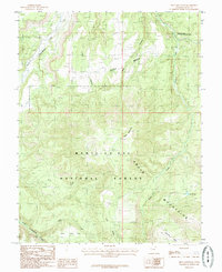
1985 Map of Shay Mountain
USGS Topo · Published 1985About this map
Newspaper Rock State Historical Monument stands as a focal point in the northeastern corner of this San Juan County landscape, marking a site of deep cultural significance where Indian Creek cuts through the high desert. The 1985 survey captures a transition from the elevated Shay Mesa and the prominent peak of Shay Mountain down into the complex drainage systems of Titus Canyon and North Cottonwood Creek. Much of the southern and central terrain is preserved within the Manti-La Sal National Forest, encompassing the rugged slopes of the Abajo Mountains. The map details a network of canyons and high ridges, such as Shay Ridge, punctuated by vital water sources like Spring Lake and various unnamed springs. This high-elevation environment is defined by its topographic relief, showing the relationship between the northern canyonlands and the forested mountain heights of the south.
Find a feature on this map
15 named features on this map. Tap any name to fly to it.
Don’t see what you’re looking for? This feature index may not catch every label — zoom into the map to look around manually.
Map Details
Editions of this 1985 Shay Mountain Map
2 editions found
Other maps of this area

1885 · La Sal
USGS Topo · 1:250,000

1886 · Abajo
USGS Topo · 1:250,000

1892 · Abajo
USGS Topo · 1:250,000

1893 · Abajo
USGS Topo · 1:250,000

1935 · Elk Ridge
USGS Topo · 1:96,000

1940 · Elk Ridge
USGS Topo · 1:125,000

1954 · Elk Ridge 1 SW
USGS Topo · 1:24,000

1954 · Elk Ridge 1 NW
USGS Topo · 1:24,000

1954 · Elk Ridge 1 NE
USGS Topo · 1:24,000

1954 · Carlisle 4 SW
USGS Topo · 1:24,000