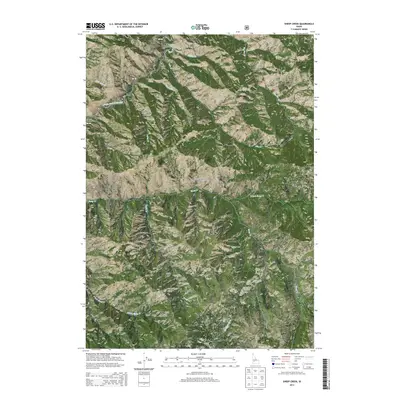
2013 Map of Sheep Creek
USGS Topo · Published 2013About this map
The Middle Fork Boise River and N Fork Boise R converge in the northwestern corner of this territory, marking a significant hydrological junction within the Boise National Forest. The landscape is defined by an intricate network of drainages, including Sheep Creek and its many branches such as the E Fork Sheep Cr and S Fork Sheep Cr. These waterways cut through the high elevations of the Boise Mountains, where Sheep Mtn serves as a prominent landmark on the eastern boundary.
Find a feature on this map
24 named features on this map. Tap any name to fly to it.
Don’t see what you’re looking for? This feature index may not catch every label — zoom into the map to look around manually.
Map Details
Editions of this 2013 Sheep Creek Map
This is the sole edition of this map. No revisions or reprints were ever made.
Other maps of this area

1894 · Idaho Basin
USGS Topo · 1:125,000

1894 · Rocky Bar
USGS Topo · 1:125,000

1955 · Hailey
USGS Topo · 1:250,000

1959 · Hailey
USGS Topo · 1:250,000

1962 · Hailey
USGS Topo · 1:250,000
1964 · Prairie
USGS Topo · 1:24,000
1964 · Trinity Mtn
USGS Topo · 1:24,000

1964 · Little Trinity Lake
USGS Topo · 1:24,000

1964 · Sheep Creek
USGS Topo · 1:24,000

1964 · Twin Springs
USGS Topo · 1:24,000