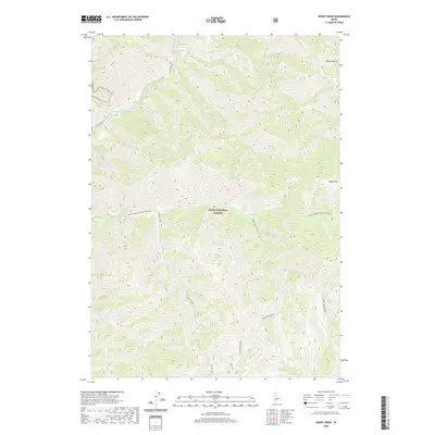
2020 Map of Sheep Creek
USGS Topo · Published 2020About this map
Boise National Forest and the William Pogue National Recreat area dominate this central Idaho landscape, where the North Fork Boise River and Middle Fork Boise River converge. The topography is defined by significant elevation changes, rising from the river canyons toward summits like Sheep Mtn. The historic Atlanta Road snakes along the riverbank, providing the primary access through this steep terrain. The drainage network is dense and complex, with numerous named seasonal and perennial flows including Devils Creek, Big Five Cr, and Rattlesnake Cr cutting through deep draws like Dobson Gulch and Bear Gulch. This 2020 survey documents the modern wilderness boundaries and access routes in the high country of Elmore County, essential for understanding the hydrology and land management of the Boise River watershed.
Find a feature on this map
29 named features on this map. Tap any name to fly to it.
Don’t see what you’re looking for? This feature index may not catch every label — zoom into the map to look around manually.
Map Details
Editions of this 2020 Sheep Creek Map
This is the sole edition of this map. No revisions or reprints were ever made.
Other maps of this area

1894 · Idaho Basin
USGS Topo · 1:125,000

1894 · Rocky Bar
USGS Topo · 1:125,000

1955 · Hailey
USGS Topo · 1:250,000

1959 · Hailey
USGS Topo · 1:250,000

1962 · Hailey
USGS Topo · 1:250,000
1964 · Prairie
USGS Topo · 1:24,000
1964 · Trinity Mtn
USGS Topo · 1:24,000

1964 · Little Trinity Lake
USGS Topo · 1:24,000

1964 · Sheep Creek
USGS Topo · 1:24,000

1964 · Twin Springs
USGS Topo · 1:24,000