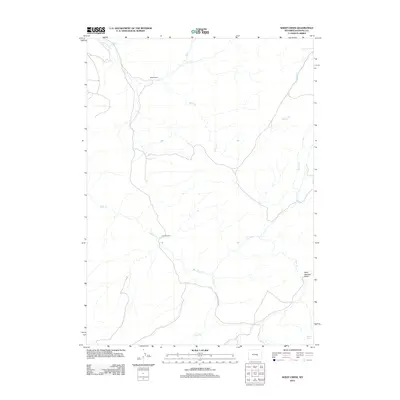
2012 Map of Sheep Creek
USGS Topo · Published 2012About this map
Milne Ranch and Steinle Ranch anchor this landscape in the southern reaches of Natrona County, where high-desert cattle ranching and water rights define the patterns of settlement. The terrain is deeply etched by a network of seasonal and perennial waterways that converge toward the south and west. Significant drainages like Bates Creek, Sheep Creek, and Chalk Creek carve through the geography, highlighting the importance of riparian corridors for survival in this arid environment. Navigation across this territory is primarily defined by the path of Bates Creek Rd, which tracks the namesake watercourse. Local landmarks such as Mud Springs Draw and Indian Spring serve as critical indicators of the local hydrology, marking points where water reaches the surface to support livestock and wildlife.
Find a feature on this map
13 named features on this map. Tap any name to fly to it.
Don’t see what you’re looking for? This feature index may not catch every label — zoom into the map to look around manually.
Map Details
Editions of this 2012 Sheep Creek Map
This is the sole edition of this map. No revisions or reprints were ever made.
Other maps of this area

1955 · Casper
USGS Topo · 1:250,000

1958 · Casper
USGS Topo · 1:250,000

1959 · Bates Creek Reservoir
USGS Topo · 1:24,000

1960 · Twin Buttes
USGS Topo · 1:24,000

1960 · Crimson Dawn
USGS Topo · 1:24,000

1960 · Horse Peak
USGS Topo · 1:24,000

1960 · Sheep Creek
USGS Topo · 1:24,000

1960 · Mud Springs
USGS Topo · 1:24,000

1960 · Ice Cave Mountain
USGS Topo · 1:24,000
1960 · Freeland
USGS Topo · 1:24,000