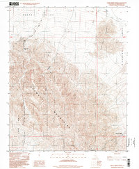
1996 Map of Sheep Creek Spring
USGS Topo · Published 1998About this map
The Avawatz Mountains dominate this high-desert landscape in the late 20th century, marking the transition between the southern reaches of Death Valley and the Silurian Valley. The map details a rugged terrain defined by significant vertical relief, where resource extraction is evident at the Sheep Cr Mine and various prospects scattered through the northern foothills. Water sources, vital in this arid environment, are specifically noted at Sheep Creek Spring and the Old Mormon Spring (Dry), the latter hinting at the historical pathways used by early travelers through the region. The southwestern portion of the sheet is occupied by the Fort Irwin Military Reservation, illustrating the intersection of public land, private mining interests, and federal defense installations. Drainages like Anvil Canyon and Salt Creek provide the primary geographical structure through the Salt Spring Hills.
Find a feature on this map
15 named features on this map. Tap any name to fly to it.
Don’t see what you’re looking for? This feature index may not catch every label — zoom into the map to look around manually.
Map Details
Editions of this 1996 Sheep Creek Spring Map
This is the sole edition of this map. No revisions or reprints were ever made.
Other maps of this area

1933 · Avawatz Mountains
USGS Topo · 1:250,000

1947 · Trona
USGS Topo · 1:250,000

1948 · Red Pass Lake
USGS Topo · 1:62,500

1948 · Trona
USGS Topo · 1:250,000

1948 · Avawatz Pass
USGS Topo · 1:62,500

1951 · Avawatz Pass
USGS Topo · 1:62,500

1951 · Red Pass Lake
USGS Topo · 1:62,500

1953 · Trona
USGS Topo · 1:250,000

1956 · Silurian Hills
USGS Topo · 1:62,500

1956 · Baker
USGS Topo · 1:62,500