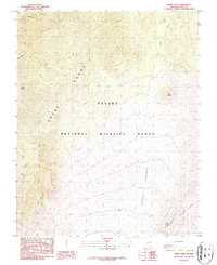
1987 Map of Sheep Peak
USGS Topo · Published 1987About this map
Sheep Range elevations dominate this high-desert landscape in the late 1980s, revealing a terrain defined by steep contours and isolated water sources. As part of the Desert National Wildlife Range, the map illustrates a network of drainage features such as Deadman Canyon and Wagon Canyon that cut through the limestone ridges. The presence of the Yucca Forest in the southeastern quadrant indicates a distinct ecological zone within these arid mountains, while the namesake Sheep Peak stands as a primary landmark. Transport through this environment is limited to the Mormon Well Road and various routes like the Pack Trail, reflecting the historic and ongoing difficulty of navigating the region. Other notable topographic features include Long Valley and the distinctive Peek-a-boo Canyon, providing specific points of reference for those studying the land use and natural history of Clark County.
Find a feature on this map
12 named features on this map. Tap any name to fly to it.
Don’t see what you’re looking for? This feature index may not catch every label — zoom into the map to look around manually.
Map Details
Editions of this 1987 Sheep Peak Map
This is the sole edition of this map. No revisions or reprints were ever made.
Other maps of this area

1907 · Las Vegas
USGS Topo · 1:250,000

1908 · Las Vegas
USGS Topo · 1:250,000

1945 · Sheep Range
USGS Topo · 1:125,000

1952 · Corn Creek Springs
USGS Topo · 1:62,500

1952 · Gass Peak
USGS Topo · 1:62,500

1954 · Las Vegas
USGS Topo · 1:250,000

1957 · Las Vegas
USGS Topo · 1:250,000

1959 · Las Vegas
USGS Topo · 1:250,000

1960 · Hayford Peak
USGS Topo · 1:62,500

1962 · Las Vegas
USGS Topo · 1:250,000