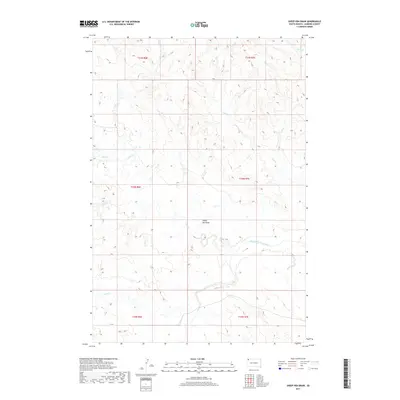
2017 Map of Sheep Pen Draw
USGS Topo · Published 2017About this map
The South Fork Grand River meanders across this corner of Harding County, defining the drainage patterns of an arid landscape in northwestern South Dakota. This section of the High Plains is characterized by a network of seasonal watercourses and topographic depressions, most notably Sheep Pen Draw, which serves as a central landmark for this sparsely populated region. The map reveals a highly structured legal landscape, with the Public Land Survey System dividing the area into townships such as t20n r6e and t20n r7e.
Find a feature on this map
15 named features on this map. Tap any name to fly to it.
Don’t see what you’re looking for? This feature index may not catch every label — zoom into the map to look around manually.
Map Details
Editions of this 2017 Sheep Pen Draw Map
This is the sole edition of this map. No revisions or reprints were ever made.
Other maps of this area

1935 · Reva
USGS Topo · 1:125,000

1954 · Lemmon
USGS Topo · 1:250,000

1957 · Lemmon
USGS Topo · 1:250,000

1968 · Ralph SW
USGS Topo · 1:24,000

1968 · Ludlow
USGS Topo · 1:24,000

1968 · Ludlow SE
USGS Topo · 1:24,000

1969 · Battleship Rock
USGS Topo · 1:24,000

1969 · Reva NW
USGS Topo · 1:24,000
1971 · Sheep Pen Draw
USGS Topo · 1:24,000
1971 · Sheep Pen Draw SW
USGS Topo · 1:24,000