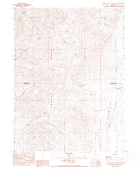
1990 Map of Sheep Ranch Canyon
USGS Topo · Published 1990About this map
The Sonoma Range dominates this landscape along the border of Humboldt and Pershing counties, where the high ridges of Spanish Basin descend into the wide expanse of the Pumpernickel Valley. This 1990 provisional survey documents a rugged ranching and mining district, anchored by the namesake Sheep Ranch situated near the mouth of Sheep Ranch Canyon. The map reveals the critical importance of water in this arid Nevada environment, marking several vital points including Buckbrush Spring, Barrel Spring, and Manganese Spring. Industrial history is represented by the Black Diablo Mine, while the agricultural needs of the valley are served by the Pumpernickel Reservoir. These features, along with names like Grand Trunk Canyon and Washoke Canyon, illustrate the patterns of land use and resource extraction that have shaped this portion of the Great Basin.
Find a feature on this map
19 named features on this map. Tap any name to fly to it.
Don’t see what you’re looking for? This feature index may not catch every label — zoom into the map to look around manually.
Map Details
Editions of this 1990 Sheep Ranch Canyon Map
This is the sole edition of this map. No revisions or reprints were ever made.
Other maps of this area

1932 · Sonoma Range
USGS Topo · 1:250,000

1939 · Sonoma Range
USGS Topo · 1:250,000

1955 · Winnemucca
USGS Topo · 1:250,000

1958 · Winnemucca
USGS Topo · 1:250,000

1958 · Winnemucca
USGS Topo · 1:62,500

1961 · Leach Hot Springs
USGS Topo · 1:62,500

1962 · Winnemucca
USGS Topo · 1:250,000

1965 · Goldrun Creek
USGS Topo · 1:24,000

1965 · Edna Mountain
USGS Topo · 1:62,500
1965 · Smelser Pass
USGS Topo · 1:24,000