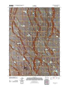
2011 Map of Sheep Rock
USGS Topo · Published 2011About this map
The High Desert of Lake County is defined here by its scarce water resources and high plateau topography. Sparse rangeland and ephemeral basins dictate the geography of this area, where named waterholes serve as the primary landmarks for navigation. From the evocatively named Impossible Waterhole to the more utilitarian Square Waterhole, these features represent vital points in an arid landscape historically used for livestock grazing. The presence of Dead Horse Lake and Walking Plow Lake further illustrates the intersection of pioneers, ranching, and the natural environment. Transportation is limited to a few arterial routes such as Burma Rd and Sheep Rock Rd, which cut through the open terrain. This survey provides a precise accounting of these small but significant hydrological points in the Oregon interior, offering a window into the pastoral and survey history of the region.
Find a feature on this map
12 named features on this map. Tap any name to fly to it.
Don’t see what you’re looking for? This feature index may not catch every label — zoom into the map to look around manually.
Map Details
Editions of this 2011 Sheep Rock Map
This is the sole edition of this map. No revisions or reprints were ever made.
Other maps of this area

1955 · Crescent
USGS Topo · 1:250,000

1955 · Klamath Falls
USGS Topo · 1:250,000

1957 · Crescent
USGS Topo · 1:250,000

1958 · Crescent
USGS Topo · 1:250,000

1958 · Klamath Falls
USGS Topo · 1:250,000

1970 · Crescent
USGS Topo · 1:250,000

1974 · Lake Abert
USGS Topo · 1:100,000
1985 · Fire Lake
USGS Topo · 1:24,000
1985 · Diatomite Reservoir
USGS Topo · 1:24,000

1986 · St. Patrick Mtn.
USGS Topo · 1:24,000