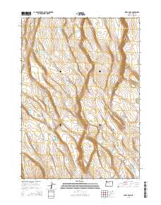
2014 Map of Sheep Rock
USGS Topo · Published 2014About this map
Sheep Rock dominates this high-desert landscape in Lake County, where the scarcity of water is evidenced by a network of uniquely named catchments and basins. Landowners and ranchers across these townships relied on vital stops like Horse Trap Waterhole, Impossible Waterhole, and Handy Waterhole to sustain livestock in an arid environment. The map details the transition from the volcanic edge of the Burma Rim down toward the seasonal basins of Dead Horse Lake and Walking Plow Lake.
Find a feature on this map
26 named features on this map. Tap any name to fly to it.
Don’t see what you’re looking for? This feature index may not catch every label — zoom into the map to look around manually.
Map Details
Editions of this 2014 Sheep Rock Map
This is the sole edition of this map. No revisions or reprints were ever made.
Other maps of this area

1955 · Crescent
USGS Topo · 1:250,000

1955 · Klamath Falls
USGS Topo · 1:250,000

1957 · Crescent
USGS Topo · 1:250,000

1958 · Crescent
USGS Topo · 1:250,000

1958 · Klamath Falls
USGS Topo · 1:250,000

1970 · Crescent
USGS Topo · 1:250,000

1974 · Lake Abert
USGS Topo · 1:100,000
1985 · Fire Lake
USGS Topo · 1:24,000
1985 · Diatomite Reservoir
USGS Topo · 1:24,000

1986 · St. Patrick Mtn.
USGS Topo · 1:24,000