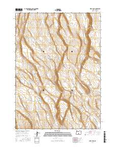
2017 Map of Sheep Rock
USGS Topo · Published 2017About this map
Sheep Rock rises above a high-desert landscape defined by scarce water resources and distinct topographic breaks in Lake County. This 2017 survey by the U.S. Geological Survey details a network of named catchment points and shallow lakes essential for land management and ranching in the Oregon high desert. The prominence of Burma Rim to the northeast creates a dramatic shift in elevation, while the surrounding basins are marked by features such as Packsaddle Lake, Dead Horse Lake, and Walking Plow Lake. The nomenclature of the area's water sources provides insight into the difficulty of the terrain and the necessity of livestock watering, with labels like Impossible Waterhole, Handy Waterhole, and Legal Waterhole indicating a history of human interaction with this arid environment.
Find a feature on this map
18 named features on this map. Tap any name to fly to it.
Don’t see what you’re looking for? This feature index may not catch every label — zoom into the map to look around manually.
Map Details
Editions of this 2017 Sheep Rock Map
This is the sole edition of this map. No revisions or reprints were ever made.
Other maps of this area

1955 · Crescent
USGS Topo · 1:250,000

1955 · Klamath Falls
USGS Topo · 1:250,000

1957 · Crescent
USGS Topo · 1:250,000

1958 · Crescent
USGS Topo · 1:250,000

1958 · Klamath Falls
USGS Topo · 1:250,000

1970 · Crescent
USGS Topo · 1:250,000

1974 · Lake Abert
USGS Topo · 1:100,000
1985 · Fire Lake
USGS Topo · 1:24,000
1985 · Diatomite Reservoir
USGS Topo · 1:24,000

1986 · St. Patrick Mtn.
USGS Topo · 1:24,000