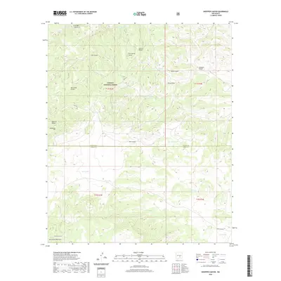
2020 Map of Sheeppen Canyon
USGS Topo · Published 2020About this map
The high-elevation drainage systems of the Sacramento Mountains define this section of the Lincoln National Forest, where the border between Lincoln and Otero counties cuts across a landscape of canyons and plateaus. Water management for livestock and wildlife is evident through a network of named catchment features such as Prairie Dog Tank, Storm Tank, and Perry Spring Tank. The map reveals a transition from deep incisions like Sheeppen Canyon and Alamo Canyon to the broader flats of the southern quadrant, where isolated water bodies like Burro Lake and Wired Lake dot the terrain. Transportation in this high-country environment is limited to specialized routes including Indian Svc Rte 66 and Hale Lake road, while landmarks like Deadhorse Hill and Cameleon Draw provide essential orientation in the complex topography of the forest interior.
Find a feature on this map
32 named features on this map. Tap any name to fly to it.
Don’t see what you’re looking for? This feature index may not catch every label — zoom into the map to look around manually.
Map Details
Editions of this 2020 Sheeppen Canyon Map
This is the sole edition of this map. No revisions or reprints were ever made.
Other maps of this area

1955 · Roswell
USGS Topo · 1:250,000

1958 · Roswell
USGS Topo · 1:250,000

1961 · Lincoln
USGS Topo · 1:62,500

1962 · Roswell
USGS Topo · 1:250,000

1963 · Fort Stanton
USGS Topo · 1:24,000

1963 · Deadman Lake
USGS Topo · 1:24,000

1963 · Ruidoso Downs
USGS Topo · 1:24,000
1963 · Pajarita Mountain
USGS Topo · 1:24,000
1963 · Whitetail
USGS Topo · 1:24,000

1984 · Ruidoso
USGS Topo · 1:100,000