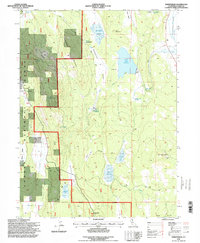
1995 Map of Sheepshead
USGS Topo · Published 1998About this map
Lassen National Forest terrain defines this section of Lassen County, where high-elevation plateaus and volcanic peaks dominate the landscape. In the mid-1990s, the area remained largely undeveloped, characterized by a complex network of springs such as Board Cabin Spring and Mule Tail Spring that feed into isolated reservoirs like Swanberger Reservoir and Heath Dam Reservoir. The presence of the Gooch Camp (Site) in Lower Gooch Valley suggests a legacy of seasonal activity or forest management in this remote district.
Find a feature on this map
44 named features on this map. Tap any name to fly to it.
Don’t see what you’re looking for? This feature index may not catch every label — zoom into the map to look around manually.
Map Details
Editions of this 1995 Sheepshead Map
This is the sole edition of this map. No revisions or reprints were ever made.
Other maps of this area

1886 · Honey Lake
USGS Topo · 1:250,000

1891 · Honey Lake
USGS Topo · 1:250,000

1893 · Honey Lake
USGS Topo · 1:250,000

1954 · Grasshopper Valley
USGS Topo · 1:62,500

1954 · Fredonyer Peak
USGS Topo · 1:62,500

1955 · Westwood
USGS Topo · 1:250,000

1956 · Hayden Hill
USGS Topo · 1:62,500

1956 · Antelope Mtn
USGS Topo · 1:62,500

1958 · Westwood
USGS Topo · 1:250,000

1959 · Westwood
USGS Topo · 1:250,000