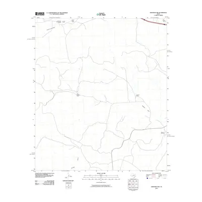
2010 Map of Sheffield NW
USGS Topo · Published 2010About this map
Canon Ranch and other established West Texas landholdings define the landscape of Pecos County in this early 21st-century survey. The terrain is characterized by a complex network of intermittent drainage paths, including Lower Fourmile Draw and Sheffield Draw, which shape the local geography and dictate the placement of ranch infrastructure. Remote operations are supported by specialized landmarks such as the Railroad Eclipse Windmill and the Canon Ranch Airport, illustrating how transportation and water access remain vital in this arid environment. Further south, the map details private holdings like Clark Brothers Ranch and Slaughter Ranch, alongside significant natural features like Bearfoot Canyon. This documentation of rural Texas provides a clear view of how large-scale ranching and industrial water infrastructure, exemplified by the Perkins Windmill, coexist with the natural topography.
Find a feature on this map
14 named features on this map. Tap any name to fly to it.
Don’t see what you’re looking for? This feature index may not catch every label — zoom into the map to look around manually.
Map Details
Editions of this 2010 Sheffield NW Map
This is the sole edition of this map. No revisions or reprints were ever made.
Other maps of this area

1929 · Sheffield
USGS Topo · 1:125,000

1929 · Independence Draw Quadrangle
USGS Topo · 1:125,000

1954 · Fort Stockton
USGS Topo · 1:250,000

1954 · Sonora
USGS Topo · 1:250,000

1958 · Sonora
USGS Topo · 1:250,000

1958 · Fort Stockton
USGS Topo · 1:250,000

1967 · Divide Country
USGS Topo · 1:24,000

1967 · Sheffield NW
USGS Topo · 1:24,000

1967 · Horsehead Canyon
USGS Topo · 1:24,000

1967 · Deer Canyon
USGS Topo · 1:24,000