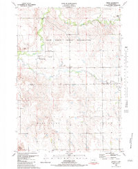
1983 Map of Shelby
USGS Topo · Published 1983About this map
Crow Creek Indian Reservation lands dominate this central South Dakota landscape, where the meandering course of Crow Creek and Smith Creek cut through the plains. The small community of Shelby sits near the center of the sheet, while the more developed area of Crow Creek to the northwest includes vital community infrastructure such as a Sewage Disposal Pond and the Crow Creek Cem. Near the northern border, St Peters Mission stands as a notable landmark alongside a Cem, indicating centers of local social and religious life.
Find a feature on this map
16 named features on this map. Tap any name to fly to it.
Don’t see what you’re looking for? This feature index may not catch every label — zoom into the map to look around manually.
Map Details
Editions of this 1983 Shelby Map
This is the sole edition of this map. No revisions or reprints were ever made.
Other maps of this area

1935 · Chamberlain
USGS Topo · 1:62,500

1939 · Chamberlain
USGS Topo · 1:62,500

1941 · Pukwana
USGS Topo · 1:62,500

1951 · Pukwana
USGS Topo · 1:62,500

1953 · Huron
USGS Topo · 1:250,000

1954 · Huron
USGS Topo · 1:250,000

1955 · Mitchell
USGS Topo · 1:250,000

1959 · Mitchell
USGS Topo · 1:250,000

1966 · Big Bend Dam SE
USGS Topo · 1:24,000

1973 · Big Bend Dam 4 SE
USGS Topo · 1:24,000
Featured Places
- West Point Township, SD
- Union Township, SD
- Pershing Township, SD
- Crow Creek District, SD
- Crow Creek, Crow Creek District