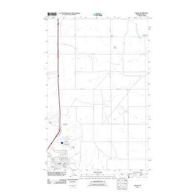
2011 Map of Shelby
USGS Topo · Published 2011About this map
Shelby serves as the focal point of this Toole County landscape, where the urban grid meets the expansive plains of northern Montana. The infrastructure of the town is clearly defined by local landmarks like the Shelby Vol Fire Dept and the Shelby Post Office, alongside the Great Northern Railway Overpass which speaks to the area's long-standing connection to the rail. North of the town center, the landscape is shaped by water management and ranching, evidenced by the Sullivan Dam and Cowpath Dam near Lake Shel-oole, and the more remote Benjamin Ranch further afield.
Find a feature on this map
29 named features on this map. Tap any name to fly to it.
Don’t see what you’re looking for? This feature index may not catch every label — zoom into the map to look around manually.
Map Details
Editions of this 2011 Shelby Map
This is the sole edition of this map. No revisions or reprints were ever made.
Other maps of this area

1920 · Conrad
USGS Topo · 1:125,000

1943 · Antelope Coulee
USGS Topo · 1:62,500

1943 · Shelby
USGS Topo · 1:62,500

1954 · Shelby
USGS Topo · 1:250,000

1958 · Shelby
USGS Topo · 1:250,000

1967 · Naismith
USGS Topo · 1:24,000

1967 · Dunkirk
USGS Topo · 1:24,000
1967 · Ledger NW
USGS Topo · 1:24,000
1984 · Conrad
USGS Topo · 1:100,000

1984 · Sweet Grass Hills
USGS Topo · 1:100,000