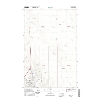
2014 Map of Shelby
USGS Topo · Published 2014About this map
Shelby serves as a vital transportation hub in this High Plains region, where the commercial core is defined by the Great Northern Railway Overpass and an intricate grid of streets including Main St and Galena St. The landscape beyond the city limits is characterized by a series of deep drainage features, notably Mead Coulee and Hall Coulee, which cut through the surrounding ranching and agricultural lands. North of the city, Lake Shel-oole provides a significant water feature in an otherwise arid environment dominated by ephemeral drainages like W Fork Willow Cr. The infrastructure of the early 21st century is well-represented by the Shelby Airport and a network of section-line roads such as Oilmont Rd S and Benjamin Rd. Genealogists may find interest in the location of the Shelby Cem, situated on the southern edge of the town center near the Marias River valley.
Find a feature on this map
54 named features on this map. Tap any name to fly to it.
Don’t see what you’re looking for? This feature index may not catch every label — zoom into the map to look around manually.
Map Details
Editions of this 2014 Shelby Map
This is the sole edition of this map. No revisions or reprints were ever made.
Other maps of this area

1920 · Conrad
USGS Topo · 1:125,000

1943 · Antelope Coulee
USGS Topo · 1:62,500

1943 · Shelby
USGS Topo · 1:62,500

1954 · Shelby
USGS Topo · 1:250,000

1958 · Shelby
USGS Topo · 1:250,000

1967 · Naismith
USGS Topo · 1:24,000

1967 · Dunkirk
USGS Topo · 1:24,000
1967 · Ledger NW
USGS Topo · 1:24,000
1984 · Conrad
USGS Topo · 1:100,000

1984 · Sweet Grass Hills
USGS Topo · 1:100,000