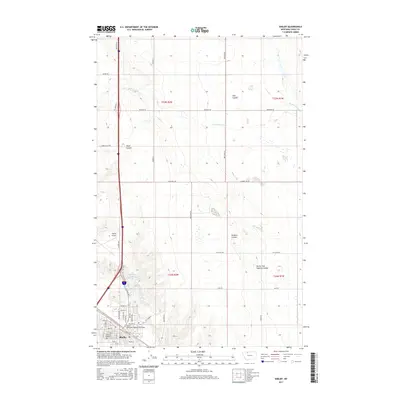
2017 Map of Shelby
USGS Topo · Published 2017About this map
Shelby serves as a vital transportation hub in Toole County, where the grid of the city meets the industrial legacy of the Great Northern Railway Overpass. The landscape is defined by its drainage patterns, with prominent erosional features like Mead Coulee, Hall Coulee, and Dunkirk Coulee carving through the high plains. Water is a focal point at Lake Shelby and along the W Fork Willow Cr, providing contrast to the dry upland terrain. This 2017 survey details the urban infrastructure from the Shelby Airport to the Mountain View Cem, alongside a network of section-line roads such as Jap Evans Rd and Gumboe Joe Rd. The map illustrates the transition from the structured residential streets like Main St and Hill Ave to the wide-open ranching and agricultural lands that surround the community.
Find a feature on this map
48 named features on this map. Tap any name to fly to it.
Don’t see what you’re looking for? This feature index may not catch every label — zoom into the map to look around manually.
Map Details
Editions of this 2017 Shelby Map
This is the sole edition of this map. No revisions or reprints were ever made.
Other maps of this area

1920 · Conrad
USGS Topo · 1:125,000

1943 · Antelope Coulee
USGS Topo · 1:62,500

1943 · Shelby
USGS Topo · 1:62,500

1954 · Shelby
USGS Topo · 1:250,000

1958 · Shelby
USGS Topo · 1:250,000

1967 · Naismith
USGS Topo · 1:24,000

1967 · Dunkirk
USGS Topo · 1:24,000
1967 · Ledger NW
USGS Topo · 1:24,000
1984 · Conrad
USGS Topo · 1:100,000

1984 · Sweet Grass Hills
USGS Topo · 1:100,000