
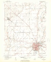
1953 Map of Shelbyville
USGS Topo · Published 1954About this map
Shelbyville dominates the southeastern corner of this mid-century survey, revealing a dense urban grid and established industrial and civic infrastructure including the Courthouse, City Hall, and the Colescott Sch. The Blue River and Brandywine Creek shape the regional topography, providing drainage for a landscape transition from structured town life to the rural townships of Moral, Marion, and Brandywine. Transportation is anchored by the New York Central railroad, which cuts diagonally through the terrain, connecting the larger hub of Shelbyville to the smaller settlement of Fairland.
Find a feature on this map
58 named features on this map. Tap any name to fly to it.
Don’t see what you’re looking for? This feature index may not catch every label — zoom into the map to look around manually.
Map Details
Editions of this 1953 Shelbyville Map
2 editions found
Other maps of this area

1942 · Columbus
USGS Topo · 1:125,000

1948 · Lewis Creek
USGS Topo · 1:24,000

1948 · Marietta
USGS Topo · 1:24,000

1950 · Edinburg
USGS Topo · 1:62,500

1952 · Fountaintown
USGS Topo · 1:24,000

1953 · Acton
USGS Topo · 1:24,000

1953 · Boggstown
USGS Topo · 1:24,000

1953 · Cincinnati
USGS Topo · 1:250,000

1956 · Morristown
USGS Topo · 1:24,000

1956 · Waldron
USGS Topo · 1:24,000