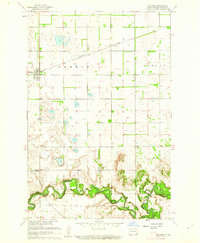
1960 Map of Sheldon
USGS Topo · Published 1962About this map
The Northern Pacific railroad corridor anchors the northern plains of Ransom County, passing through the established town of Sheldon. At this time in the early 1960s, the landscape is defined by the sharp contrast between the rectilinear section lines of the upland prairies and the winding, heavily vegetated valley of the Sheyenne River. This southern waterway serves as a focal point for local transportation, marked by several named crossings such as the McClellan Bridge, Legg Bridge, and Larson Bridge. These landmarks, alongside the small settlement of Anselm, illustrate the rural infrastructure supporting the Missouri River Basin's development. The map meticulously records the transition from the open fields of Greene and Coburn townships to the more complex terrain of Shenford and Owego along the river bluffs, where small-scale industry like a Gravel Pit is also visible.
Find a feature on this map
12 named features on this map. Tap any name to fly to it.
Don’t see what you’re looking for? This feature index may not catch every label — zoom into the map to look around manually.
Map Details
Editions of this 1960 Sheldon Map
This is the sole edition of this map. No revisions or reprints were ever made.
Other maps of this area

1895 · Casselton
USGS Topo · 1:125,000

1897 · Tower
USGS Topo · 1:125,000

1897 · Casselton
USGS Topo · 1:125,000

1907 · Wyndmere
USGS Topo · 1:125,000

1953 · Fargo
USGS Topo · 1:250,000

1956 · Fargo
USGS Topo · 1:250,000

1960 · Coburn
USGS Topo · 1:24,000

1960 · Lisbon NE
USGS Topo · 1:24,000

1960 · Enderlin South
USGS Topo · 1:24,000

1960 · Venlo
USGS Topo · 1:24,000