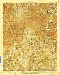
1927 Map of Shell Knob
USGS Topo · Published 1927About this map
The White River and James River wind through a landscape defined by sharp ridges and deep hollows in this 1925 survey. This era predates the major dam projects that would later transform the Ozark river valleys, showing the original winding watercourses punctuated by numerous crossings like Schreiner Ferry and Byron Carr Ford. The map reveals a highly decentralized rural society, where small mountain communities like Mano and Golden are supported by an extensive network of country schools, including Cedar Mound School, Mountain Home School, and McGuire School.
Find a feature on this map
76 named features on this map. Tap any name to fly to it.
Don’t see what you’re looking for? This feature index may not catch every label — zoom into the map to look around manually.
Map Details
Editions of this 1927 Shell Knob Map
3 editions found
Other maps of this area

1900 · Eureka Springs
USGS Topo · 1:125,000

1901 · Eureka Springs
USGS Topo · 1:125,000

1904 · Harrison
USGS Topo · 1:125,000

1905 · Harrison
USGS Topo · 1:125,000

1907 · Forsyth
USGS Topo · 1:125,000

1927 · Shell Knob
USGS Topo · 1:62,500

1937 · Cassville
USGS Topo · 1:48,000

1942 · Aurora
USGS Topo · 1:62,500

1943 · Monett
USGS Topo · 1:62,500

1944 · Cassville
USGS Topo · 1:62,500