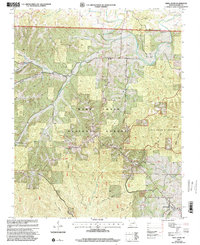
1999 Map of Shell Knob
USGS Topo · Published 2002About this map
Mark Twain National Forest dominates this Ozark landscape, where the wooded ridges and hollows are carved by Flat Creek and Piney Creek. This late 20th-century revision captures a rural network of small settlements like Cato, Hailey, and Hill City, alongside the expanding community at Shell Knob. Genealogists will find a wealth of local markers, including the Epperly Mem Cem and the Snyder Cem, while the Fairview Sch and Mt View Ch point to the historic community centers of Barry County. The eastern portion of the map is preserved as the Piney Creek Wilderness, featuring a primitive trail system including the Piney Creek Trail and Woods Trail. The terrain is characterized by deep hollows like Galena Hollow and Bean Hollow, which define the drainage patterns feeding into the larger creek systems that eventually reach the Table Rock Lake region just beyond these borders.
Find a feature on this map
42 named features on this map. Tap any name to fly to it.
Don’t see what you’re looking for? This feature index may not catch every label — zoom into the map to look around manually.
Map Details
Editions of this 1999 Shell Knob Map
This is the sole edition of this map. No revisions or reprints were ever made.
Other maps of this area

1927 · Shell Knob
USGS Topo · 1:62,500

1937 · Cassville
USGS Topo · 1:48,000

1942 · Aurora
USGS Topo · 1:62,500

1943 · Monett
USGS Topo · 1:62,500

1944 · Cassville
USGS Topo · 1:62,500

1945 · Harrison
USGS Topo · 1:250,000

1945 · Aurora
USGS Topo · 1:62,500

1949 · Harrison
USGS Topo · 1:250,000

1950 · Shell Knob
USGS Topo · 1:62,500

1954 · Harrison
USGS Topo · 1:250,000