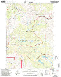
1993 Map of Shell Reservoir
USGS Topo · Published 1997About this map
Bighorn National Forest provides the setting for this high-altitude landscape, where drainage patterns from the Sheridan Co Big Horn Co line flow into the West Fork South Tongue River and Shell Creek. The 1993 field check documents a wilderness character defined by remote water bodies like Adelaide Lake and Lake Arden, and the prominent high-country topography of Bruce Mountain and Dome Peak. A distinctive transition is visible between the open forest and the strictly managed Cloud Peak Wilderness boundary. Local infrastructure is minimal, centered on the Ranger Creek Ranch and the Adelaide Trail, highlighting the area's primary use for recreation and watershed management. Several Gaging Sta markers and an Electronic Site on the peaks suggest the importance of this terrain for hydrologic monitoring and communication in the Big Horn Mountains.
Find a feature on this map
34 named features on this map. Tap any name to fly to it.
Don’t see what you’re looking for? This feature index may not catch every label — zoom into the map to look around manually.
Map Details
Editions of this 1993 Shell Reservoir Map
2 editions found
Other maps of this area

1895 · Dayton
USGS Topo · 1:125,000

1898 · Bald Mountain
USGS Topo · 1:125,000

1899 · Cloud peak
USGS Topo · 1:125,000

1901 · Cloud Peak
USGS Topo · 1:125,000

1901 · Dayton
USGS Topo · 1:125,000

1901 · Bald Mountain
USGS Topo · 1:125,000

1955 · Sheridan
USGS Topo · 1:250,000

1958 · Sheridan
USGS Topo · 1:250,000

1960 · Shell Falls
USGS Topo · 1:24,000

1960 · Shell Lake
USGS Topo · 1:24,000