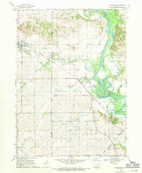
1968 Map of Shellsburg
USGS Topo · Published 1971About this map
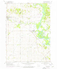
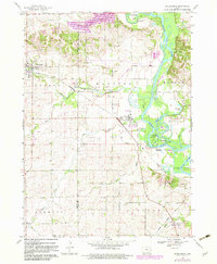
Shellsburg and Palo serve as the primary hubs in this late 1960s landscape, which is defined by the sweeping course of the Cedar River and a network of intersecting rail lines. The Chicago Rock Island and Pacific railroad cuts diagonally across the terrain, passing through the heart of both settlements. This era captures the region's agricultural and industrial character, with several active Quarry sites and Grave Pits distributed near the river and rail corridors. Local heritage is deeply rooted here, evidenced by the presence of numerous small burying grounds like Strawn Cem and Spring Grove Cem. The riparian environment along the river provides a distinct ecological contrast to the surrounding farm townships, featuring landmarks such as Mud Lake, Horseshoe Lake, and the extensive Halo Marsh County Park. Smaller watercourses, including Bear Creek and Lone Tree Creek, further define the topography across the Benton and Linn County border.
Find a feature on this map
37 named features on this map. Tap any name to fly to it.
Don’t see what you’re looking for? This feature index may not catch every label — zoom into the map to look around manually.
Map Details
Editions of this 1968 Shellsburg Map
3 editions found
Other maps of this area

1887 · Cedar Rapids
USGS Topo · 1:62,500

1888 · Shellsburg
USGS Topo · 1:62,500

1888 · Marion
USGS Topo · 1:62,500

1888 · Amana
USGS Topo · 1:62,500

1889 · Marion
USGS Topo · 1:62,500

1889 · Amana
USGS Topo · 1:62,500

1889 · Shellsburg
USGS Topo · 1:62,500

1891 · Cedar Rapids
USGS Topo · 1:62,500

1899 · Amana
USGS Topo · 1:62,500

1899 · Shellsburg
USGS Topo · 1:62,500