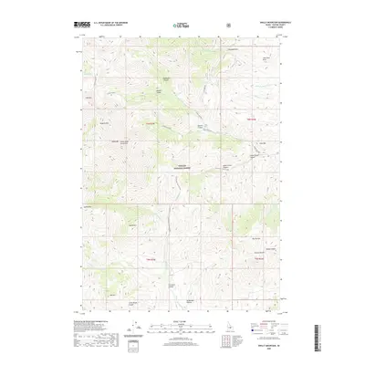
2020 Map of Shelly Mountain
USGS Topo · Published 2020About this map
The White Knob Mountains dominate this Custer County landscape, where high-altitude drainages and canyons define the topography of the Challis National Forest. High peaks including Shelly Mtn, Redbird Mtn, and Lime Mtn form a perimeter around an intricate network of gulches and draws. Historically significant corridors such as Alder Creek Rd and Cliff Creek Rd provide access to interior features like Upper Brown Canyon and Lower Brown Canyon. The map reveals a land utilized for its natural resources and rugged isolation, marked by seasonal water sources like Mud Lake and the Middle Fork Cherry Cr. Significant landmarks such as Flower Garden and Big Flat Top indicate a terrain of varied alpine plateaus and deep-set canyons like Mammoth Canyon, providing a detailed record of this remote Idaho wilderness in the early twenty-first century.
Find a feature on this map
44 named features on this map. Tap any name to fly to it.
Don’t see what you’re looking for? This feature index may not catch every label — zoom into the map to look around manually.
Map Details
Editions of this 2020 Shelly Mountain Map
This is the sole edition of this map. No revisions or reprints were ever made.
Other maps of this area

1935 · MacKay
USGS Topo · 1:96,000

1940 · Mackay
USGS Topo · 1:62,500

1955 · Idaho Falls
USGS Topo · 1:250,000

1958 · Idaho Falls
USGS Topo · 1:250,000

1960 · Muldoon Canyon
USGS Topo · 1:62,500

1960 · Grouse
USGS Topo · 1:62,500

1960 · Mackay
USGS Topo · 1:62,500

1960 · Copper Basin
USGS Topo · 1:62,500
1988 · Arco
USGS Topo · 1:100,000
1991 · Mackay
USGS Topo · 1:24,000