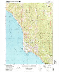
1997 Map of Shelter Cove
USGS Topo · Published 1999About this map
Shelter Cove sits at the edge of the Pacific Ocean on this late-twentieth-century survey, centered on the dramatic coastal landscape of the King Range National Conservation Area. The settlement at Point Delgada is shown in detail, featuring infrastructure like the Pacific Landing Strip, a Filtration Plant, and Sewage Disposal facilities. Inland, the map reveals a wilderness of steep ridges and deep gulches, including Dead Mans Gulch and the prominent Horse Mountain Ridge.
Find a feature on this map
41 named features on this map. Tap any name to fly to it.
Don’t see what you’re looking for? This feature index may not catch every label — zoom into the map to look around manually.
Map Details
Editions of this 1997 Shelter Cove Map
This is the sole edition of this map. No revisions or reprints were ever made.
Other maps of this area

1920 · Pt. Delagda
USGS Topo · 1:62,500

1921 · Briceland
USGS Topo · 1:62,500

1949 · Eureka
USGS Topo · 1:250,000

1949 · Point Delgada
USGS Topo · 1:62,500

1949 · Garberville
USGS Topo · 1:62,500

1950 · Piercy
USGS Topo · 1:62,500

1951 · Garberville
USGS Topo · 1:62,500

1951 · Point Delgada
USGS Topo · 1:62,500

1957 · Ukiah
USGS Topo · 1:250,000

1958 · Redding
USGS Topo · 1:250,000