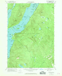
1966 Map of Shelving Rock
USGS Topo · Published 1970About this map
Lake George dominates the western portion of this mid-1960s survey, revealing a complex shoreline defined by the Tongue Mountain Range and a dense archipelago of islands including the Mother Bunch Islands, Big Burnt Island, and Floating Battery Island. The terrain is characterized by steep ascents to peaks such as Erebus Mtn and Black Mtn, the latter featuring a lookout tower. Settlement is sparse, concentrated primarily at Pilot Knob along the water and the interior hamlet of Hogtown. The map illustrates the protected boundaries of Adirondack State Park, where the local road network, including Shelving Rock Road and Dublin Road, transitions into primitive trails. For the genealogist or local historian, the presence of a Cem near the southeastern corner provides a specific point for tracing early inhabitants of the Fort Ann township.
Find a feature on this map
85 named features on this map. Tap any name to fly to it.
Don’t see what you’re looking for? This feature index may not catch every label — zoom into the map to look around manually.
Map Details
Editions of this 1966 Shelving Rock Map
3 editions found
Other maps of this area

1893 · Fort Ann
USGS Topo · 1:62,500

1893 · Whitehall
USGS Topo · 1:62,500

1895 · Whitehall
USGS Topo · 1:62,500

1895 · Fort Ann
USGS Topo · 1:62,500

1895 · Glens Falls
USGS Topo · 1:62,500

1897 · Bolton
USGS Topo · 1:62,500

1897 · Glens Falls
USGS Topo · 1:62,500

1898 · Whitehall
USGS Topo · 1:62,500

1898 · Fort Ann
USGS Topo · 1:62,500

1900 · Bolton
USGS Topo · 1:62,500