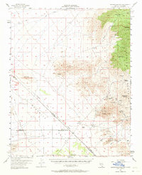
1956 Map of Shenandoah Peak
USGS Topo · Published 1964About this map
Mining operations dominate the landscape of the eastern Spring Mountains during this mid-century survey of the Nevada-California borderlands. The rugged topography is etched with the names of high-altitude claims and industrial sites, including the Potosi Mine and the Keystone Mine. In the valley floor to the south, the settlement at Sandy and the Ripley (Site) represent the shifting centers of local habitation and resource extraction. Evidence of the area's logistical infrastructure is preserved through the Traction Road, a small Landing Field, and the Shenandoah Mill. The map also meticulously traces the Von Schmidt Line, marking the historical boundary between Clark Co. and San Bernardino Co., while family-named landmarks like the Singer Mine and McVicar Mine offer specific points of interest for genealogical research.
Find a feature on this map
60 named features on this map. Tap any name to fly to it.
Don’t see what you’re looking for? This feature index may not catch every label — zoom into the map to look around manually.
Map Details
Editions of this 1956 Shenandoah Peak Map
3 editions found

Other maps of this area

1907 · Las Vegas
USGS Topo · 1:250,000

1908 · Las Vegas
USGS Topo · 1:250,000

1910 · Ivanpah
USGS Topo · 1:250,000

1912 · Ivanpah
USGS Topo · 1:250,000

1942 · Ivanpah
USGS Topo · 1:250,000

1947 · Kingman
USGS Topo · 1:250,000

1948 · Kingman
USGS Topo · 1:250,000

1952 · Blue Diamond
USGS Topo · 1:62,500

1954 · Las Vegas
USGS Topo · 1:250,000

1954 · Kingman
USGS Topo · 1:250,000