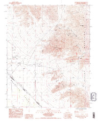
1985 Map of Shenandoah Peak
USGS Topo · Published 1985About this map
The Spring Mountains tower over a landscape defined by 20th-century mining and desert settlement along the border of Nevada and California. In the mid-1980s, this region of the Mesquite Valley was dotted with numerous workings, ranging from the Keystone Mine and Chiquita Mine in the northern heights to the Bill Nye Mine tucked into the eastern slopes. The presence of the Ripley (Site) and infrastructure like the Shenandoah Mill and Sandy Mill points to a history of industrial processing tied directly to these mineral claims.
Find a feature on this map
32 named features on this map. Tap any name to fly to it.
Don’t see what you’re looking for? This feature index may not catch every label — zoom into the map to look around manually.
Map Details
Editions of this 1985 Shenandoah Peak Map
2 editions found
Other maps of this area

1910 · Ivanpah
USGS Topo · 1:250,000

1912 · Ivanpah
USGS Topo · 1:250,000

1942 · Ivanpah
USGS Topo · 1:250,000

1947 · Kingman
USGS Topo · 1:250,000

1948 · Kingman
USGS Topo · 1:250,000

1954 · Kingman
USGS Topo · 1:250,000

1955 · Kingman
USGS Topo · 1:250,000

1955 · Roach Lake
USGS Topo · 1:62,500

1956 · Clark Mountain
USGS Topo · 1:62,500

1956 · Shenandoah Peak
USGS Topo · 1:62,500