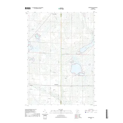
2018 Map of Shennington
USGS Topo · Published 2018About this map
Shennington and Wyeville anchor this central Wisconsin landscape, where the Lemonweir River and Council Creek wind through a complex system of marshes and managed waterways. The terrain is defined by its extensive water management, featuring significant impoundments like the Monroe County Flowage and Eagle Nest Flowage, alongside an intricate network of drainage channels such as Cutler Ditch and Mud Ditch. This 2018 survey reveals the persistent rural character of the area, punctuated by quiet settlements and local landmarks. Genealogists will find interest in the documented locations of Saint Johns Cem near the Monroe and Juneau County line, as well as Saint Peters Cem further south. The map illustrates a landscape shaped by both natural river courses and intentional water diversion, with forest trails like Blueberry Trl weaving through the wetlands between Norway Ridge and the Beaver Creek drainage.
Find a feature on this map
42 named features on this map. Tap any name to fly to it.
Don’t see what you’re looking for? This feature index may not catch every label — zoom into the map to look around manually.
Map Details
Editions of this 2018 Shennington Map
This is the sole edition of this map. No revisions or reprints were ever made.
Other maps of this area

1919 · Kendall
USGS Topo · 1:62,500

1921 · Mauston
USGS Topo · 1:62,500

1921 · Kendall
USGS Topo · 1:62,500

1953 · Eau Claire
USGS Topo · 1:250,000

1958 · Eau Claire
USGS Topo · 1:250,000

1958 · Necedah
USGS Topo · 1:48,000

1958 · Wyeville
USGS Topo · 1:48,000

1958 · La Crosse
USGS Topo · 1:250,000

1961 · La Crosse
USGS Topo · 1:250,000

1962 · Kendall
USGS Topo · 1:62,500