
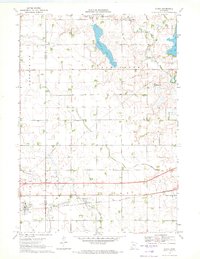
1970 Map of Sherburn
USGS Topo · Published 1972About this map
The town of Sherburn serves as a central hub in this Southern Minnesota landscape, where the Chicago Milwaukee ST Paul And Pacific railroad intersects with north-south lines. The region is defined by its glaciated hydrology, featuring prominent water bodies such as the expansive Fox Lake and the smaller Temperance Lake just east of the village. Significant drainage modifications are evident through the network of the Judicial Ditch No 37 and others, which have transformed former wetlands like the Munger Lakebed and Manyaska Lakebed into productive agricultural land. Local heritage is preserved at sites like St Lukes Cem and Emmanuel Ch., while the rural economy is reflected in numerous Gravel Pits and the Powerplant on the southern shore of the lake. The map also captures a moment of infrastructure planning with the Location Proposed for what would become Interstate 90, cutting across the prairie between Sherburn and Welcome.
Find a feature on this map
36 named features on this map. Tap any name to fly to it.
Don’t see what you’re looking for? This feature index may not catch every label — zoom into the map to look around manually.
Map Details
Editions of this 1970 Sherburn Map
This is the sole edition of this map. No revisions or reprints were ever made.
Other maps of this area

1954 · Fairmont
USGS Topo · 1:250,000

1958 · Fairmont
USGS Topo · 1:250,000

1970 · St James SE
USGS Topo · 1:24,000

1970 · Ceylon
USGS Topo · 1:24,000

1970 · Trimont
USGS Topo · 1:24,000

1970 · Mountain Lake SE
USGS Topo · 1:24,000

1970 · Welcome
USGS Topo · 1:24,000

1970 · Dunnell
USGS Topo · 1:24,000

1970 · Wilbert
USGS Topo · 1:24,000
1970 · Alpha
USGS Topo · 1:24,000