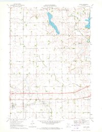
1970 Map of Alpha
USGS Topo · Published 1972About this map
The village of Alpha sits at the southwestern edge of this 1970s survey, a small settlement defined by its position along the Chicago Milwaukee St Paul and Pacific railroad line. The surrounding landscape in Jackson and Martin Counties is heavily managed for agriculture, evidenced by an extensive network of drainage systems including Judicial Ditch No 32 and Judicial Ditch No 15. These channels weave through a glaciated terrain of scattered water bodies such as Watkins Lake, Big Twin Lake, and Duck Lake. To the south, the East Fork Des Moines River cuts through the township of Jay, while the northern portion is dominated by the course of Elm Creek. This map captures a rural Minnesota prairie landscape at the height of its mid-century agricultural development, where natural watercourses and man-made ditches intersect to sustain the fertile farmland.
Find a feature on this map
18 named features on this map. Tap any name to fly to it.
Don’t see what you’re looking for? This feature index may not catch every label — zoom into the map to look around manually.
Map Details
Editions of this 1970 Alpha Map
This is the sole edition of this map. No revisions or reprints were ever made.
Other maps of this area

1954 · Fairmont
USGS Topo · 1:250,000

1958 · Fairmont
USGS Topo · 1:250,000

1970 · Jackson NW
USGS Topo · 1:24,000

1970 · Ceylon
USGS Topo · 1:24,000

1970 · Jackson
USGS Topo · 1:24,000

1970 · Trimont
USGS Topo · 1:24,000

1970 · Mountain Lake SE
USGS Topo · 1:24,000
1970 · Bergen
USGS Topo · 1:24,000

1970 · Dunnell
USGS Topo · 1:24,000

1970 · Sherburn
USGS Topo · 1:24,000