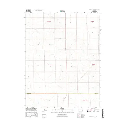
2016 Map of Sheridan Lake SE
USGS Topo · Published 2016About this map
The county line between Kiowa Co and Prowers Co bisects this high plains landscape, defined by a rigid grid of rural roads and the intermittent drainage of Buffalo Cr. In the southern portion of the map, the terrain begins to slope toward the creek bed, while the northern sections are marked by subtle elevation changes typical of the eastern Colorado plains. This 2016 survey documents the enduring Public Land Survey System structure, with township lines like t19s r44w and t20s r43w guiding the placement of local connectors such as Co Rd 66 and Co Rd G. The sparse distribution of named water features and the prominence of the boundary line along Co Rd WW underscore the importance of political and property divisions in this agricultural region.
Find a feature on this map
22 named features on this map. Tap any name to fly to it.
Don’t see what you’re looking for? This feature index may not catch every label — zoom into the map to look around manually.
Map Details
Editions of this 2016 Sheridan Lake SE Map
This is the sole edition of this map. No revisions or reprints were ever made.
Other maps of this area

1890 · Granada
USGS Topo · 1:125,000

1892 · Granada
USGS Topo · 1:125,000

1894 · Granada
USGS Topo · 1:125,000

1954 · Lamar
USGS Topo · 1:250,000

1955 · Granada NW
USGS Topo · 1:24,000

1955 · Granada NE
USGS Topo · 1:24,000
1955 · Holly NW
USGS Topo · 1:24,000

1958 · Lamar
USGS Topo · 1:250,000

1968 · Stuart
USGS Topo · 1:24,000

1968 · Sheridan Lake
USGS Topo · 1:24,000