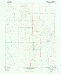
1968 Map of Sheridan Lake SE
USGS Topo · Published 1971About this map
The high plains of eastern Colorado are captured here in the late 1960s, defined by the dry drainage of Buffalo Creek and a landscape engineered for water access and resource extraction. The boundary between Kiowa Co and Prowers Co bisects the southern portion of the map, marking a transition in this rural territory where isolated infrastructure like a Radio Tower and various Wells dot the terrain. Human activity is sparse but specialized, evidenced by a Sandpit and a single structure labeled Shack, suggesting a period when local industry and ranching required only intermittent outposts. This survey provides a clear look at the agricultural and utility network of the region, featuring several installations for livestock and irrigation such as a Water Tank and a Well Water Tank to sustain life in the semi-arid environment.
Find a feature on this map
9 named features on this map. Tap any name to fly to it.
Don’t see what you’re looking for? This feature index may not catch every label — zoom into the map to look around manually.
Map Details
Editions of this 1968 Sheridan Lake SE Map
This is the sole edition of this map. No revisions or reprints were ever made.
Other maps of this area

1890 · Granada
USGS Topo · 1:125,000

1892 · Granada
USGS Topo · 1:125,000

1894 · Granada
USGS Topo · 1:125,000

1954 · Lamar
USGS Topo · 1:250,000

1955 · Granada NW
USGS Topo · 1:24,000

1955 · Granada NE
USGS Topo · 1:24,000
1955 · Holly NW
USGS Topo · 1:24,000

1958 · Lamar
USGS Topo · 1:250,000

1968 · Stuart
USGS Topo · 1:24,000

1968 · Sheridan Lake
USGS Topo · 1:24,000